
Our experience, your best work tool.
Our Aplications
Explore our software solutions for land surveying and civil engineering and enhance your projects.
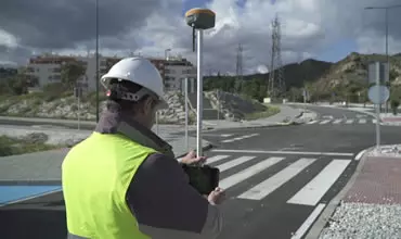
EASIER FIELD WORK
Easily perform all types of data capture, survey and stakeout work using GPS/GNSS receivers.

TOPOGRAPHIC PROJECTS
Complete solution in CAD, which allows you to model the terrain of a plot of land to elaborate road or urbanization projects.
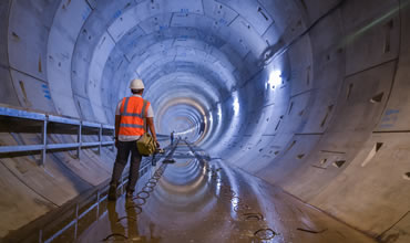
RIGOROUS CONTROL OF TUNNEL WORKS
Execute easily and accurately the construction of tunnels for roads, railroads, subways and mines, with total station or 3D scanner.
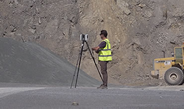
Point Clouds
Use point clouds from scanner, LiDAR or photogrammetry, as well as orthophotos, digital elevation models and aerial images in your projects.
Solutions by Industry
Discover the industries where we operate
In Aplitop, we offer tailored solutions to various sectors, such as water and energy, cadastre, building, civil engineering, environment, and many others.

Advantages
Discover the advantages of incorporating our solutions into your workflow.
Ease of Use
Get started effortlessly thanksAdvantages to our short learning curve and start producing from the get-goo.
User Experience
Immerse yourself in our ecosystem designed to optimize your workflow and get exactly what you need.
Technical Support
Become an additional member of the Aplitop team. Find constant support and fast and efficient tools for your problems.
Technical Support
Our service is recommended by 98% of customers.
INTOPCO
Regarding technical and commercial support, yours is the best and we feel at home. Thank you for your time, disposition and kindness.
Camilo Maldonado
Technical Office Coordinator
AZVI NORGE
Aplitop solutions are worthy of a wide range of adjectives to stand out among them, useful, versatile and dynamic. Another plus point of Aplitop solutions are the constant improvements that they develop based on the suggestions received by customers and their extensive experience in the sector.
Joan Gonzalez Pi
Head surveyor/BIM manager
MRTOOLS
The experience and deep knowledge of the working methods of users in the Iberian Peninsula are for us the guarantee that Aplitop products are best suited for our customers.
Pedro Matos e Ribeiro
Manager
LEPONT Equipements
The Aplitop solution allows having a powerful software with a measured budget. Our main customers are surveyors or design offices but also other atypical customers such as NATO which is part of our Tcp MDT customers because the TcpMDT solution allows them in the field to create a DTM, level curves and draw colour gradients according to the measured slopes.
Fabrice Moulin
Sales & Support Engineer - Topography - Construction – Detection
GEOCOM
All the solutions offered by our company must meet the requirement of being world-class solutions and Aplitop is no exception, its various computer applications have various tools that are easy to implement, and Aplitop has the vision of making constant improvements with great First-line support, additionally in our language, which is a great plus for all Spanish-speaking users.
Pablo Ortega
Product Mapping Manager

KRCP Consulting
I would like to start by announcing that the presentation of the project in which you collaborated with the topographic part has been highly successful and for that purpose let me thank you in my name and on behalf of KRCP Consulting for the effort you made during these 3 weeks and your interaction to move the work forward.
Ouafia Khali
Technical support. Architect
EXCADE
Easy application, intuitive, very pleasant to work with. Excellent support.
Adrián Cue
Surveyor

DIPUTACIÓN DE SEVILLA
You are always improving and the support when I need it, I have it. Thank you. Best regards
Juan Luis Blázquez Manzano
Engineer Surveyor

Grupo COPISA
I am very happy with the product, but above all with the excellent attention and quick response to the issues found
Rubén Rojo
Topography Chief
COFOPRI
I´m very grateful for the quick and concrete answers that make your support service one of the best I have experienced. I made the changes that they recommended me and I was finally able to create the project and see it in 3D.
Frank Saavedra
Deputy Director of Geodesy and Survey
EmbraTop
The technical Support is very good, quickly and precise answers about TcpScancyr and TcpTunnel.
Daniel Alves
New Technology Manager
HERCAL
Thankful for the attention received, solving my query initially via chat and then sending me a video tutorial with the process to follow.
Manuel Sánchez
Surveying Manager
PRODIEL
Excellent technical support, on one occasion my company’s information department didn’t know how to install the software and you resolved the problems.
Alicia Gómez
Civil Engineering
Topomar Topógrafos
I have 7 licenses of it and we works around the world in many projects and if you have any problem you can contact by telephone, skype and if you have any problem with a file you can send them and the give you the solution.
Melchor J. Aguilar
Chief Executive Officer
SATOCAN
I´m very satisfied with the technical support service. I would recommend it, without any doubt, the TcpMDT application. Thanks.
Agustín Cesar García
Surveyor
Construcciones Rubau
I'm really satisfied with the technical support, not only now but you have provided a high level of support for years. Congratulations to the entire team for your work.
Antonio Romero
Technical Office Manager
GeoMax Iberia, S.L.
Their technical support has high quality, and they devote themselves to make improvements suggested by users constantly.
Agustín López Doval
Commercial Director
FERROVIAL AGROMAN S.A.
However the best aspect of this application agreement, is the great attitude of the technical support personal. They have diligently and quickly worked to solve all the challenges that we have posed to them to date.
Luis Santiago Moratinos
Technical Direction
SACYR
They give high quality technical support, and they deploy improvements suggested by our users. These programs are approved by the company for use in all kinds of projects.
Antonio Esteban
Surveying Chief
European Regional Development Fund.
APLITOP S.L. has been a beneficiary of the European Regional Development Fund whose objective is to improve the use and quality of information and communication technologies and access to them and thanks to which it has optimized our commercial processes for the improvement of competitiveness and productivity of the company 2022. For this, it has had the support of the INNOCAMARA PROGRAM of the Chamber of Commerce of Malaga. "A way of making Europe".