Performs simple and accurate execution control for tunnel projects for roads, railroads, subways and mines, with total station or 3D scanner.
Construction field solutions
TcpTunnel
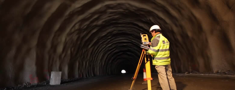
Control of tunnel works with total station
TcpTunnel can be installed in a wide range of motorized total stations, or in a data collector.
The cross sections are measured automatically, simply giving the desired interval and the number of points per profile. The application shows the theoretical and measured tunnel section, with top and front views displaying infra and over-excavation areas.
It also has functions for setting out the front, pavement or tunnel profiles, checking control points, calculating areas, etc.
TcpTunnel Scan for Topcon
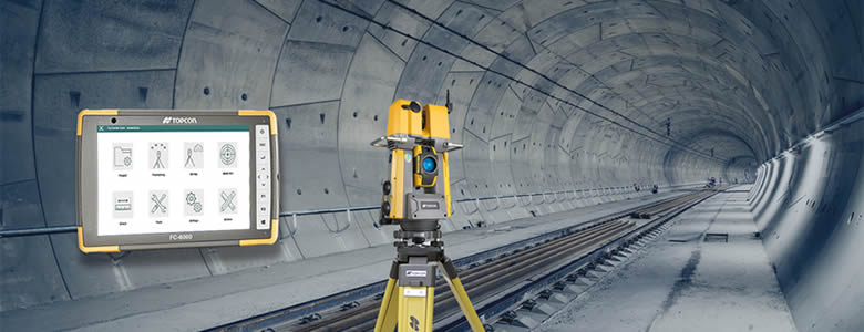
Real-time Control Tunneling Software
TcpTUNNEL Scan installs on a Windows tablet connected to the scanning robotic total station TOPCON GTL-1000.
The software commands the scanning of the tunnel vault or face and show the point cloud in a powerful 3D viewer. High definition tunnel cross-sections are calculated, and they can be compared to the tunnel design, showing the underbreak and overbreak areas. Selecting any point of the profile on the screen, the laser pointer marks the position in the tunnel and vice versa.
TcpTUNNEL Scan facilitates the stake out of the tunnel front, for example the drill hole points for the next blasting excavation sequence, points on the template, rock bolts, road surface and more.
Office solutions


TcpTunnel CAD
Analysis of tunnel data measured by total station
This CAD application processes tunnel surveying data measured by total stations running TcpTunnel or other programs.
TcpTunnel CAD calculates from the points and alignment the cross sections, that can be filtered and edited, and allows you to compare with the tunnel template drawn as a polyline. You can also draw profiles in single or sheet mode with multiple customization options, as well as generate the 3D model of the tunnel.
The application also calculates infra or over-excavation areas and volumes, generating reports that can be printed or exported to various formats.
TcpScancyr
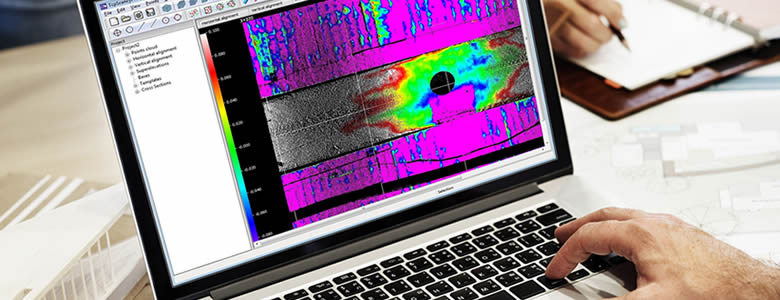
Analysis of tunnel data captured by terrestrial scanner
This powerful application calculates tunnel cross sections for roads or railways, based on laser scanner data.
Starting from the point cloud, cross sections are calculated, which can be modified by a powerful editor. They can be displayed in 2D or 3D, showing the infra and over-excavation zones, and can also be exported to DXF, with multiple customization options.
The program also generates other results such as area and volume reports, deviation of the real alignment, inspection map, orthoimages and video simulation of the tunnel.
| Feature | Tcp TUNNEL CAD | Tcp Scancyr |
|---|---|---|
| Import of LandXML and other file formats | ||
| Drawing of cross sections | ||
| Area and volume reports | ||
| Generation of 3D model | ||
| Export as-built tunnel to IFC | ||
| Point cloud editing | ||
| Alignment deviation report | ||
| Inspection map | ||
| Orthoimage | ||
| Virtual tour |
We can help you
Need help? Click on the following button to contact us and we will be happy to assist you.
Related products
tcpMDT Standard

Software for surveying, terrain modeling, contours, profiles and volumes.
tcpMDT Professional

Software for surveying, civil engineering, architecture and construction projects
European Regional Development Fund.
APLITOP S.L. has been a beneficiary of the European Regional Development Fund whose objective is to improve the use and quality of information and communication technologies and access to them and thanks to which it has optimized our commercial processes for the improvement of competitiveness and productivity of the company 2022. For this, it has had the support of the INNOCAMARA PROGRAM of the Chamber of Commerce of Malaga. "A way of making Europe".
Funded by the European Union NextGenerationEU.
APLITOP S.L. has benefited from the INTERNATIONAL MENTORING Programme to improve and consolidate its international positioning through the implementation of an International Action Plan. The programme is financed by European Next Generation-EU funds, as part of the Recovery, Transformation and Resilience Plan.
Compromiso con el Medio Ambiente
Midiendo el futuro con sostenibilidad. Implementamos medidas responsables para reducir las emisiones de CO₂ el desarrollo de nuestras soluciones