


GPS/GNSS receiver
Use your mobile device for data collection or stakeout and work in all kind of surveying and civil projects.
Surveying the Future
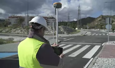
Easily perform all types of data capture, survey and stakeout work using GPS/GNSS receivers.

Complete solution in CAD, which allows you to model the terrain of a plot of land to elaborate road or urbanization projects.
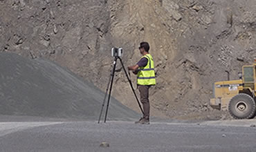
Use point clouds from scanner, LiDAR or photogrammetry, as well as orthophotos, digital elevation models and aerial images in your projects.
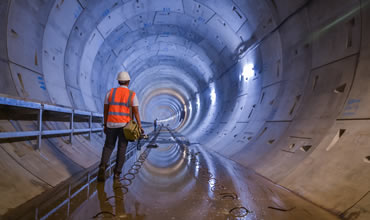
Execute easily and accurately the construction of tunnels for roads, railroads, subways and mines, with total station or 3D scanner.
In Aplitop, we offer tailored solutions to various sectors, such as water and energy, cadastre, building, civil engineering, environment, and many others.


Aplitop solutions allows us to have powerful software with a competitive budget. Our main clients are surveyors or design offices, but other unique clients such as NATO are also part of our customer base because the TcpMDT solution allows them to create a DTM in the field, contour lines, and color gradients according to measured slopes.
I am truly satisfied with the technical support, not only now, but because you have maintained a high level for years. Congratulations to the entire team for your work.
Very good in treatment and efficiency.
All the solutions offered by our company must meet the requirement of being world-class solutions, and Aplitop is no exception. Its various software applications include tools that are easy to implement. In addition, Aplitop has the vision of continually improving with strong first-line support, and being available in our language is a great plus for all Spanish-speaking users.
Very satisfied with the support service. Thank you. I would undoubtedly recommend the tcpMDT application.
You are always improving, and when I need support, I have it. Thank you. Best regards.
In Croatia, the State Geodetic Administration a few years ago changed the coordinate system which we used for many years (HDKS5(6)/GK) to a new (HTRS96/TM) coordinate system. So, we need to transform lots of cadastral maps and surveying drawings to a new coordinate system.
View details
APLITOP S.L. has been a beneficiary of the European Regional Development Fund whose objective is to improve the use and quality of information and communication technologies and access to them and thanks to which it has optimized our commercial processes for the improvement of competitiveness and productivity of the company 2022. For this, it has had the support of the INNOCAMARA PROGRAM of the Chamber of Commerce of Malaga. "A way of making Europe".
APLITOP S.L. has benefited from the INTERNATIONAL MENTORING Programme to improve and consolidate its international positioning through the implementation of an International Action Plan. The programme is financed by European Next Generation-EU funds, as part of the Recovery, Transformation and Resilience Plan.
Midiendo el futuro con sostenibilidad. Implementamos medidas responsables para reducir las emisiones de CO₂ el desarrollo de nuestras soluciones