This template is intended to check a 3D surface imported from a DXF file containing 3D faces or a LandXML containing surfaces entities. To carry out this check, the dimension defined on the surface will be compared with the elevation measured by the GPS and the difference will be shown. In addition, the face on which the GPS is located at each moment is highlighted.
In the Layer management section is possible to change the active layer in case the project contains multiple surface layers. The active surface layer will be the one taken for making the analysis.
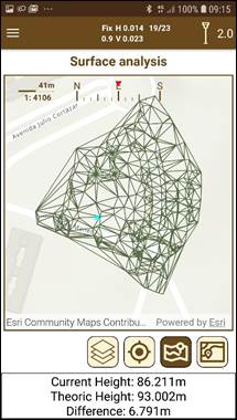
The information shown is:
·Height: Current height of the GNSS receiver.
·Height diff.: Difference of height between the GNSS height and the current selected surface.