Aplitop | Land Surveying and Civil Engineering Software - list-news

aplitop-spinning

News

2013
Maintenance Contract Promotion

Maintenance Contract Promotion

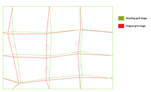
All new users who sign up or extend the maintenance contract will receive for free the MDT images module, valued at € 495. MDT Images can work on digital images, georreferenced or not, in a wide variety of formats. It is specially designed for projects in which are frequent to work with aerial photographies, orthophotos and scanned maps in ...

2013
TcpMDTCAD

TcpMDTCAD

TcpMDT-CAD is a software designed for those professionals looking for a tool for the implementation of projects of Surveying and Civil Engineering addition without purchasing an expensive CAD license. It is based on ZWCAD + technology, a proven CAD ​​solution with over 320,000 customers worldwide. It is based on the standard DWG, and the look and ...

2013
MDT in Chinese

MDT in Chinese

Continuing the policy of international expansion APLITOP, we announced the availability of MDT 6.5 in Chinese. Previously it was delivered in Spanish, English, European Portuguese, Brazilian Portuguese and Basque. Besides translation, there have been some adjustments to the presentation styles and road regulations used in China, having had the col ...

2013
MDT Point Cloud

MDT Point Cloud

Announcing the release of MDT Point Cloud, a new module that enables the users to view and process point clouds created by LIDAR technology or conventional scanners.   Points can be viewed in natural colour, intensity or category. The amount percentage of points to be displayed and the pixel size of the points can be controlled.   The ...

2012
MDT for BricsCAD V13

MDT for BricsCAD V13

Announcing compatibility of MDT version 6.5 with BriscCAD V13, so that MDT features can be run on this platform. With BricsCAD one dwg-based CAD platform takes care of all your needs from simple 2D drafting to advanced 3D direct modeling. No need for companion products or conversions. Plus industry-leading support and a compelling price.

2012
Distort Image  with rubber-sheeting

Distort Image with rubber-sheeting

Now it’s included a new algorithm for distortion of images, very suitable for archaeological projects, scanned maps and others. In rubber-sheeting technique a number of regions are computed using known origin and destination point coordinates. A bilinear transformation is applied to each of the cells of the generated grid, and we obtain the resulti ...

2012
MDT now available for ZWCAD+

MDT now available for ZWCAD+

This new version has improved stability, increased ease of use and advanced localization, which gives users a more fluid experience. With these updates, designers will be able to better take advantage of the new and superior kernel and complete their work faster and more efficiently. New APIs has allowed us to achieve full compatibility, and our ...

2012

E57 Point clouds in TcpScancyr

Latest version now supports this new laser scanner point cloud data, which aims to become a new standard for the exchange of such data, and it’s rapidly being adopted by manufacturers of hardware and software. The E57 committee of the ASM (American Society for Testing and Materials) that belongs APLITOP handles issues about 3D imaging systems and l ...

2012
Announcing the release of TcpTunnel CAD version 1.6.2 for AutoCAD 2013

Announcing the release of TcpTunnel CAD version 1.6.2 for AutoCAD 2013

This add-on module to TcpTunnel lets you to draw cross sections measured by this software installed in total stations or compatible data collectors. Also it can process coordinate files from other applications, in order to compute tunnel infra and over-excavation areas and volumes, generate reports…

2012

Release of TcpGPS Version 4

Announcing the release of version 4 of our application for surveys and setting out using GNSS receivers.   With a completely renewed interface, maps can now be loaded as background in DXF or Shape formats and georeferenced images in JPG, ECW or JPEG 2000. If you have Internet access, you can add Web Map Services (WMS) data sources.   ...

Can we help you?